


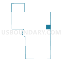
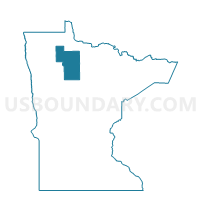
Unorg. Dist. 2, Beltrami County, Minnesota
About
Outline

Summary
| Unique Area Identifier | 601166 |
| Name | Unorg. Dist. 2 |
| County | Beltrami County |
| State | Minnesota |
| Area (square miles) | 35.74 |
| Land Area (square miles) | 35.74 |
| Water Area (square miles) | 0.00 |
| % of Land Area | 100.00 |
| % of Water Area | 0.00 |
| Latitude of the Internal Point | 48.06244390 |
| Longtitude of the Internal Point | -94.48821900 |
Maps

Graphs
Select a template below for downloading or customizing gragh for Unorg. Dist. 2, Beltrami County, Minnesota


Neighbors
Neighoring Voting District (by Name) Neighboring Voting District on the Map
- Forest Grove Precinct, Koochiching County, MN
- Kelliher Twp. Voting District, Beltrami County, MN
- Shotley Twp. Voting District, Beltrami County, MN
- Waskish Twp. Voting District, Beltrami County, MN
- West Koochiching Voting District, Koochiching County, MN
- Woodrow Twp. Voting District, Beltrami County, MN
Top 10 Neighboring County Subdivision (by Population) Neighboring County Subdivision on the Map
- Northwest Koochiching UT, Koochiching County, MN (463)
- Northome UT, Koochiching County, MN (447)
- Kelliher township, Beltrami County, MN (130)
- Waskish township, Beltrami County, MN (118)
- Woodrow township, Beltrami County, MN (73)
- Shotley township, Beltrami County, MN (35)
- Shotley Brook UT, Beltrami County, MN (25)